Change Detection with Precision: SAR Imagery in Action
Synthetic Aperture Radar (SAR) has revolutionized remote sensing, offering an unparalleled ability to pierce through cloud cover and capture data day and night. Unlike optical imagery reliant on clear skies and sunlight, SAR acts as an all-weather eye in the sky. This remarkable capability makes SAR images invaluable for monitoring Earth's surface, providing crucial insights into aide range of changes. From the scars of deforestation hidden beneath dense jungle canopies to floodwaters obscured by heavy rain, SAR provides vital data for monitoring a vast array of phenomena. This information proves particularly valuable for tracking natural disasters, charting urban growth, and understanding complex ecological shifts.
Despite the numerous advantages of SAR imagery, a significant obstacle arises when attempting to use it for change detection over time: speckle noise. This inherent, grainy texture is a byproduct of the coherent nature of SAR signals and can obscure the very changes we seek to identify. Traditional methods for change detection often struggle with speckle noise, leading to inaccurate or misleading results. This limitation necessitates the development of more sophisticated techniques for change detection with SAR imagery.
By leveraging Change Former, we can achieve a new level of accuracy and robustness identifying true changes within SAR images. ChangeFormer is a cutting-edge deep learning architecture specifically designed for change detection tasks, particularly suited for SAR image analysis. Unlike traditional methods that require extensive pre-processing and hand-crafted features, ChangeFormer learns directly from the data. Its sophisticated architecture allows it to filter out complex, irrelevant changes caused by atmospheric variations and, crucially, speckle noise. This filtering capability empowers Change Former for various types of change detection with SAR images, making it a powerful tool for applications across diverse fields.
Disaster Monitoring: Rapid Response and Damage Assessment:
In the aftermath of natural disasters such as floods, earthquakes, landslides, or wildfires, rapid and accurate damage assessment is crucial for effective response and relief efforts. By analyzing pre- and post-disaster SAR images, we can identify changes in the landscape with exceptional precision. This allows for the rapid identification of areas with collapsed buildings from earthquakes, flooded zones, landslide scars, and burned areas from wildfires. The resulting "change mask" – an image overlay highlighting the exact regions of significant alterations – empowers emergency responders to prioritize areas requiring immediate attention, saving lives and minimizing property loss.
Forest Fire in Indonesia:
Landslides in Iceland:

Urban Planning and Development: Charting City Growth:
The rapid pace of urbanization necessitates innovative tools for tracking city growth and land-use trends. By comparing SAR images acquired over time, we can identify emerging trends in land use. This allows urban planners to monitor the expansion of residential areas, track infrastructure development (roads, buildings), and identify areas undergoing significant change. This information enables informed decision making regarding future development plans, ensuring sustainable urban growth.
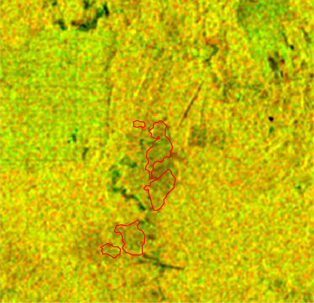
Building change in Taiwan:

Monitoring in Agriculture: Tracking Ecosystems and Land Use:
The health and sustainability of agricultural practices are intricately linked to the well-being of our planet. By analyzing SAR images, we can monitor changeling agricultural landscapes and wetland ecosystems.
Sample in Taiwan

The proposed Change Former network for CD:
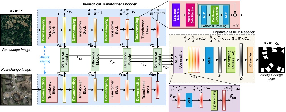
Change Former Network consists of three main modules:
- Hierarchical Transformer Encoder:
This acts as the brain of Change Former. Inspired by the Transformer architecture used in natural language processing, it analyzes both're- and post-disaster images simultaneously. It extracts features at different levels – course details like overall shapes and fine-grained specifics like textures. The "Siamese" aspect ensures both images are processed identically, maintaining a separate understanding of each.
- Multi-Scale Feature Difference Modules:
Imagine these modules as detectives meticulously comparing the extracted features. They operate at various scales, like zooming in and out on an image. This allows them to identify changes of all sizes – from subtle texture shifts indicating a small fire scar to drastic transformations like collapse building. By comparing features at different scales, ChangeFormer builds a comprehensive picture of the discrepancies between the images.
- Lightweight Multi-Layer Perception Decoder:
This final stage acts as the translator. It takes thematic-scale difference features, which might be complex and hard to interpret, and combines them. Think of it as weaving a tapestry from different threads. By analyzing the relationships between these features, the decoder learns to differentiate between random variations and actual changes. Finally, it translates this understanding into a clear "mask" – an image overlay highlighting the exact regions where significant changes have occurred.
By learning directly from data and filtering out noise, Change Former empowers researchers and practitioners across diverse fields. It offers a powerful tool for monitoring Earth's ever-changing landscapes, from rapid disaster response to sustainable agricultural practices, encompassing tracking crop health inland use, all the way to urban planning and development through charting city growth.
DOWNLOAD NOW


